
|
Use Virtual Research To Find
|
||||||||||||||||||
|
I remember 20 or 30 years ago when "Train Spotting" was the thing that set model railroaders all a twitter and for many of them, it was an adventure to sit by an outlying section of track with an interesting physical feature and wait for a train to enter the scene for a quick 5-10 photos. Who could have imagined that a couple of decades later "Ship Spotting" would bring ship modelers from all over the world right to the dock where their revered original is tied up. All without leaving their desk! Enter Google Earth! |
|||
|
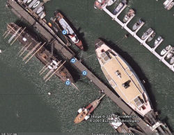
Use it to zip up to Boothbay Harbor, Me where you will find the HMS Bounty under wraps going through phase two of her restoration in preparation for sailing this summer. Not really that much to see here. Flash across the country to San Francisco’s Hyde Street Pier where you will find the 1886 Square Rigger Balbutha tied up to the pier with six lines. Just ahead of her on the opposite side is the C.A. Thayer awaiting her next rebuild process. |
|
||
|
The 1895 Schooner, C.A. Thayer, subject of a two-year, $9 million restoration almost from the keel up. She is a 219-foot, wooden-hulled, three-masted schooner, designed for carrying lumber from Washington and Oregon to San Francisco. The pier next door is home for the SS Jeremiah O'Brien which was a Liberty ship during World War II. It is one of only two remaining Liberty ships that is still operational today. Just ahead of the O'Brien is the USS Pampanito (SS-383), a Balao-class submarine, the only ship of the United States Navy to be named for the gafftopsail pompano, Trachinotus rhodopus. She is now preserved as a memorial and museum ship in San Francisco. |
|||
Virtual Research Has Other Modeling Options
| |||
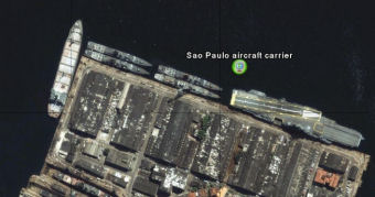
| As a research tool, Google Earth and its competing earth mappers can almost take you aboard a ship about anywhere in the world where you can actually see the physical details up close and personal without leaving your desk. So how do you locate all of these vessels? You have to tell Google Earth where to go. This takes a visit www.shipspotters.com, an active database of 327,175 photos of ships anywhere in the world. What a tool. | |||
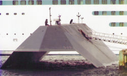
| For instance, drop in on the Sea Shadow's dock in San Diego. 10 years ago, this was a pretty hush hush Navy project, but she'd make an interesting scale model today. . Revell has one. Sea Shadow was built in 1985 and used in secret but in normal service until its public debut in 1994, to examine the application of stealth technology on naval vessels. In addition, the ship would test the ability to man a ship with fewer men and more automation.. | | ||
| The ship was created by the Defense Advanced Research Projects Agency (DARPA), the U.S. Navy and Lockheed. Sea Shadow was developed at Lockheed's Redwood City, California facility, inside the Hughes Mining Barge, which functioned as a floating drydock during construction and testing. She is sometimes incorrectly referred to as "USS Sea Shadow," but she was never a full commissioned ship of the US Navy. | |||
Google Earth and Microsoft's Virtual Earth provide about the same resolution and similar mapping databases. They are both in BETA form and downloadable at no cost to the user. Get one and explore the world. | |||

SBI!
